"Beats Flex-fragment design special edition" is now on sale on Apple's official website
11/03/2022

Bridges installed on urban expressways have limited takeoff and landing locations, making it difficult to inspect with conventional drones. Furthermore, under the bridge, it is difficult for the drone to acquire GPS information, and advanced maneuvering techniques have been required to avoid collisions with piers and the like.
Based on the above situation, North American drone maker Skydio has developed a drone "Skydio 2" that can take off and land in a narrow space and fly stably without GPS information. In response to this, NTT DoCoMo started providing services using Skydio 2 in Japan on November 13, 2020.
NTT Docomo is conducting "Infrastructure Inspection / Infrastructure Inspection" in the comprehensive construction exhibition "Maintenance Resilience OSAKA 2021" (Date: July 14-16, 2021, INTEX Osaka) with the theme of maintenance and national resilience. At the "Maintenance Exhibition", we showed a service using Skydio 2 and the aircraft.
Skydio 2 is a 4K camera mounted on the top and bottom of the aircraft, sensing all directions to control the aircraft and detect and avoid obstacles, so GPS information can be obtained under bridges, etc. Even if you can't, you can fly stably. The main camera of the 3-axis gimbal attached to the top of the aircraft can be turned 180 degrees, so you can shoot parts that were difficult to shoot until now.
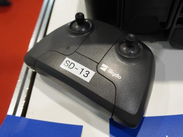
"Skydio 2" "Skydio 2" controllerThe operation corresponds to the maneuvering using the controller and the dedicated application, and also corresponds to the autonomous flight of the flight route created in advance. The maximum flight time is 23 minutes and the maximum speed is 58 km / h.
The person in charge of NTT DoCoMo said, "Skydio 2 is easy to handle even for beginners because it can control the aircraft and detect and avoid obstacles by omnidirectional sensing with the installed 4K camera, and train drone operators. It is also useful for. "
There are three types of Skydio 2 services provided by NTT DoCoMo: "technical verification," "operation verification," and "one-year rental."
Technical verification confirms the usefulness of Skydio 2, including planning to confirm the functions of Skydio 2, providing shooting data, preparing reports, demonstrating Skydio 2 by professional operators, and flying in a dedicated program. It consists of trials of AI analysis, drone function expansion software "Skydio Autonomy Enterprise Foundation (AEF)" and flight support software "Skydio 3D Scan".
AEF displays the camera angle on the operation screen of the dedicated application and sets the "Vertical View" that adjusts the angle of view of the camera up to 90 degrees and the detection range of the 4K camera that recognizes obstacles. It is equipped with "Close Proximity Obstacle Avoidance".
Skydio 2 (left) with the camera angle of view set to 90 degrees in "Vertical View" and images taken with the camera angle facing up at 90 degrees Source: NTT DoCoMoIn addition, it is equipped with functions such as "Visual Return-to-Home" that returns the drone to the default location even in an environment where GPS is difficult to acquire, and it is a place where it was difficult to fly or shoot in the past. However, it contributes to flying the drone while shooting the object efficiently and safely.
"Skydio 3D Scan is created in advance while avoiding obstacles based on the data acquired by the upper and lower 6 4K cameras by letting Skydio 2 recognize the shape even in environments and complicated structures that are difficult for GPS to acquire. In addition to being able to automatically fly the route that was taken, it is also possible to limit the shooting range and flight area of Skydio 2 to improve the safety of inspection work, "said a person in charge at NTT Docomo.
Operation verification is to check whether the drone is effective in business, and consists of Skydio 2 rental, Skydio 2 and drone knowledge training, NTT DoCoMo's drone platform "docomo sky", AEF, and Skydio 3D Scan. ..
"Vertical Viewer" of "docomo sky"docomo sky is a cloud-type platform that can be accessed from a browser. "Vertical Viewer" that visualizes the altitude from images acquired by a drone and "AMY INSIGHT" made by Automagi that visualizes rust. ) ”, Fujifilm's“ Hibimikke ”system that extracts cracks is installed.
The one-year rental consists of Skydio 2 rental and docomo sky, AEF, and Skydio 3D Scan. The price starts from 750,000 yen for technical verification, and individual estimates for operational verification and one-year rental.